Large car park at Rowardennan on the east shore of Loch Lomond. Charges apply (£5/day, payable via Ringo app). Very popular — on busy summer days it can be full by 10am. If the car parks at Balmaha and Rowardennan fill, police may close the road entirely.
If there’s one Munro almost every hillwalker in Scotland has climbed, it’s Ben Lomond. Around 30,000 people reach the summit every year, making it comfortably the most popular Munro in the country. And it’s easy to see why — it’s under an hour from Glasgow, the path is well-maintained, the views over Loch Lomond are stunning, and at 974m it’s a proper mountain without being intimidating.
I’ve been up Ben Lomond a few times now, in different seasons and different conditions, and each time has been a slightly different experience. It’s the kind of mountain that rewards repeat visits — familiar enough to feel like coming home, but the weather and the light always make it feel fresh.
Route Overview
- Ben Lomond — Munro — Beacon Mountain — 974m
- Total distance: 12.5km (tourist path up and down)
- Total ascent: 956m
- Moving time: ~4 hours
- Difficulty: Moderate — well-maintained paths, steep final section
There are two main route options here. The tourist path is the standard ascent — well-marked, well-maintained, and the route most people take up and down. The Ptarmigan Ridge is a more interesting but steeper alternative that can be used for the descent to make it a circuit. I’d recommend going up the tourist path and coming down via the Ptarmigan Ridge if you’re comfortable with steeper, rougher terrain.
Getting There and Parking
The hike starts from the car park at Rowardennan, on the east shore of Loch Lomond. It costs £5 for the day, payable via the Ringo app — worth having that downloaded before you arrive as signal can be patchy.
This is the single most important piece of advice for Ben Lomond: arrive early. On a sunny summer weekend, a fair-weather Saturday can easily have 200+ people heading up, and the car park fills fast. On my most recent visit it was nearly full by 10am. If both the Balmaha and Rowardennan car parks fill up, the police will close the road entirely and you won’t even get in. A 7:30am arrival on weekends is a good target.
From Glasgow, it’s about 50 minutes up the A811 and then along the east side of the loch. From Edinburgh, allow around 90 minutes.
The Tourist Path — Rowardennan to the Summit
You start by walking through the small visitor centre area where there’s a toilet block and a place to fill your water bottles. A signpost marks the start of the path — you can’t miss it.
The first section climbs gently through beautiful mixed oak woodland. It’s a lovely start to the day — sheltered, green, and nothing too demanding. The path is beautifully maintained here, a mix of compact gravel and stone steps. After crossing a small bridge, you emerge from the trees and the first views of Loch Lomond open up behind you.
You’ll reach a junction where the Ptarmigan Ridge path splits off to the right. For the tourist path, continue straight ahead. The gradient picks up from here but remains steady rather than brutal — nothing like the relentless steepness of Ben More further north.
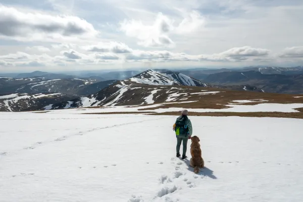
As you climb higher, the path becomes stonier and the views just keep expanding. Loch Lomond stretches out below you with its scatter of islands, and on a clear day you can see right across to the Luss Hills on the far shore. This is the stretch where you’ll want your camera out — every time you gain another 50 metres of elevation, the panorama gets a bit more impressive.
The final push to the summit is the steepest section. The path zigzags up a rocky, sometimes muddy slope and the last 200m of ascent can feel like a proper slog, especially if the weather has turned and the wind picks up. But it’s short and well-trodden — just keep putting one foot in front of the other.
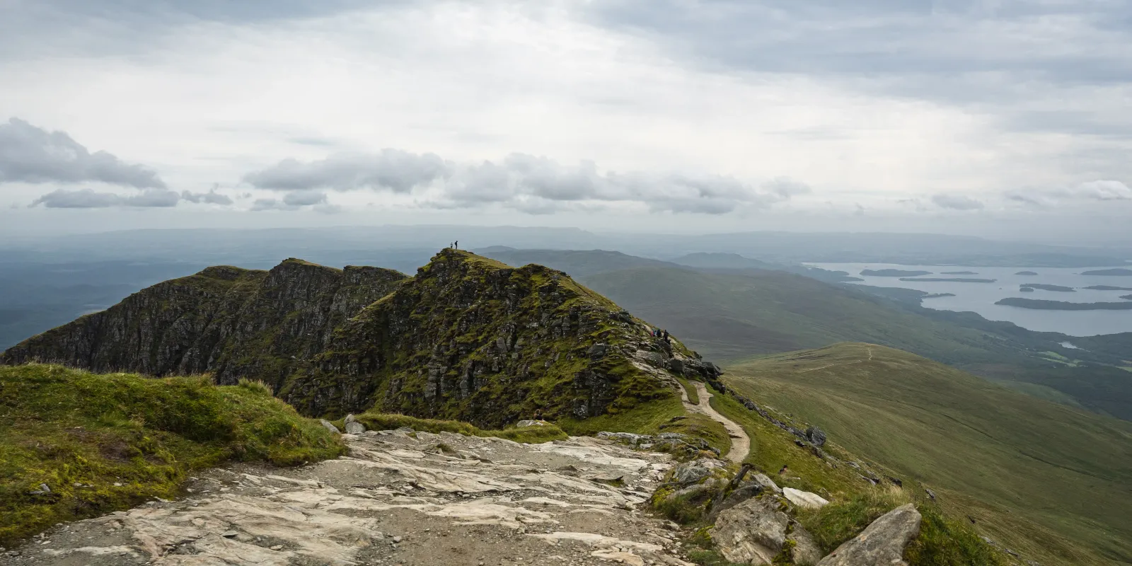
Ben Lomond Summit — 974m
The summit is marked by a trig point and there’s usually a crowd up here on any decent day. But don’t let that put you off — the views are genuinely spectacular and worth sharing.
On a clear day, the panorama is enormous. To the north you can see as far as Ben Lawers and the Breadalbane hills. To the north-east, Ben Vorlich and Stuc A’ Chroin are prominent. The Arrochar Alps — including Beinn Ime and Beinn Narnain and Ben Vane — dominate the western view beyond the loch. To the south, you can see the Clyde Valley and, on a really clear day, the Isle of Arran.
It’s a summit where you want to linger. We found a sheltered spot just below the trig point, demolished our sandwiches, and spent a good 20 minutes just taking it all in.
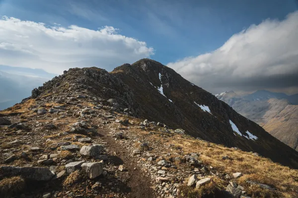
The Ptarmigan Ridge — Alternative Descent
If you want to make this a circuit rather than a straight up-and-down, the Ptarmigan Ridge is the way to go. From the summit, head south along the ridge rather than retracing your steps on the tourist path.
The initial descent off the summit is steep and can be loose in places — take your time, especially if it’s wet. Once you’re on the ridge proper, the path narrows and becomes rougher than the tourist path, but it’s straightforward navigation and the views are arguably even better from this angle. You get a completely different perspective of Loch Lomond with the islands laid out below you.
The ridge eventually drops down through woodland and meets back up with the tourist path near the junction you passed on the way up. From there it’s a short walk back to the car park.
The Ptarmigan Ridge adds a bit more distance and takes longer than simply descending the tourist path, but it’s well worth it for the variety and the views. I’d recommend it for anyone who’s comfortable on steeper, less-maintained ground — it’s not a scramble, but it’s noticeably rougher than the tourist path.
When to Climb Ben Lomond
Summer (May–September) is when Ben Lomond is at its busiest and its most accessible. Long daylight hours mean you can start later and still have plenty of time. The downside is the crowds — if you want a quieter experience, midweek is significantly better than weekends.
Autumn (October–November) is arguably the best time. The crowds thin out, the bracken turns golden, and on a crisp clear day the visibility can be extraordinary. Shorter days mean you need to be more disciplined about timing, but the mountain is at its most photogenic.
Spring (March–April) can be mixed — you might get lingering snow on the upper slopes, boggy conditions lower down, and the weather is unpredictable. But catch a good day and you’ll have the mountain largely to yourself.
Winter (December–February) transforms Ben Lomond into a more serious proposition. Snow and ice on the upper slopes and the summit ridge require crampons and an ice axe, and the Ptarmigan Ridge becomes significantly more exposed. Don’t be fooled by the “easy Munro” reputation — in full winter conditions, allow 50% extra time and make sure you have the skills and gear to match.
What to Bring
Whilst this is one of the more accessible Munros, I’ve seen a surprising number of people caught out by the conditions every time I’ve been up. People in trainers on a wet, muddy summit. People in t-shirts with no extra layers when the cloud rolls in and the temperature drops 10 degrees.
Ben Lomond deserves the same respect as any other mountain. I’d recommend having a look at the Munro Checklist for a full breakdown of what to bring. At a minimum: proper walking boots, waterproof jacket and trousers, extra layers, plenty of water, and food. The weather at 974m can be completely different from the car park — even on a sunny day, the summit can be cold and windy.
Combine With
Ben Lomond is typically a standalone day out — the 956m of ascent is enough for most people. But the Loch Lomond area has plenty of other walks and Munros if you’re staying for a few days. Ben Vane is a short drive north in the Arrochar Alps, and Beinn Ime and Beinn Narnain are accessible from Arrochar village, about 40 minutes by car.
For something lower-level, Conic Hill from Balmaha is a brilliant shorter hike with incredible views over Loch Lomond and the Highland Boundary Fault.
Tips for This Route
- Arrive by 7:30am on summer weekends. The car park fills and the road can be closed. Midweek is dramatically quieter.
- Download the Ringo app for parking payment before you arrive — phone signal at Rowardennan is unreliable.
- Go up the tourist path, down the Ptarmigan Ridge. It makes the day more interesting and the ridge views are worth the extra effort.
- Bring more layers than you think you need. The summit is regularly 10°C colder than the car park and exposed to wind.
- Don’t underestimate the conditions. This is still a 974m mountain. Every time I’ve been up, I’ve seen people turning back because they weren’t prepared for the weather.
Frequently Asked Questions
How hard is Ben Lomond? It’s one of the more accessible Munros thanks to the well-maintained tourist path, but it’s still a proper mountain with 956m of ascent. Most reasonably fit people can manage it — expect it to take 4–6 hours round trip. The final section to the summit is the steepest part.
Is Ben Lomond good for beginners? Yes — along with Schiehallion and The Cairnwell Munros, it’s one of the best introductions to Munro bagging. The path is clear, the navigation is straightforward, and the sense of achievement at the top is enormous. Just make sure you’re properly equipped.
Where do you park for Ben Lomond? Rowardennan car park on the east shore of Loch Lomond. £5/day via the Ringo app. Arrive early on weekends — if it fills, the police close the road.
Can you see Ben Nevis from Ben Lomond? On a very clear day, yes — you can see the outline of Ben Nevis to the north, though it’s a long way off. The more prominent summit views are the Arrochar Alps, the Breadalbane hills, and the full length of Loch Lomond.
Is Ben Lomond suitable for dogs? Yes, dogs are welcome. The tourist path is manageable for most dogs, though the steep upper section and the Ptarmigan Ridge are rougher going. Keep your dog on a lead — there are signs requesting this due to grazing livestock, and it’s especially important during lambing season (April–May).
What’s the best time to climb Ben Lomond? Autumn (October–November) for the best combination of fewer crowds, golden light, and clear visibility. Summer for the longest days and most reliable weather, though you’ll share the mountain with hundreds of other people.